Jamb Geography Past Questions For Year 1998
Question 1
\(\begin{array}{c|c}
Month & J& F & M & A & M & J & J & A & S & O & N & D\\
\text{Temp(C)} & -22 & -22 & -21 & -4 & 2 & 5 & 5 & 1 & 1 & -4 & -10 & 17 \\
\text{Precip(mm)} & 10 & 13 & 18 & 18 & 15 & 13 & 13 & 28 & 28 & 28 & 28 & 13 \\
\end{array}\)
The climatic region represented above is
- A. Laurentian
- B. Siberian
- C. Arctic
- D. Steppe
Question 2

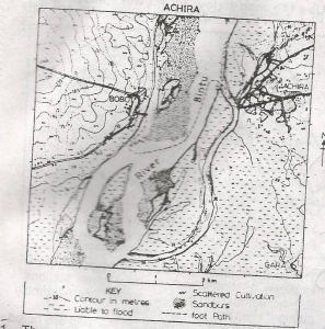
The most important factor that probably explains the distribution of cultivation on the mapped area is
- A. Drainage
- B. Settlement
- C. Road
- D. Climate
Question 3

Motorists will probably cross the river from Bobo to Achira by
- A. Drawbridge
- B. Ship
- C. Boat
- D. Ferry
Question 4

To build a road from Achira to Gara will require
- A. A cutting
- B. An embarkment
- C. A tunnel
- D. A levee
Question 5

The low islands and extensive sand banks indicate that the channel of River Bintu is probably
- A. Deep
- B. Eroding
- C. Shallow
- D. Navigable