Jamb Geography Past Questions For Year 1993
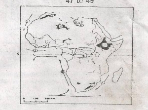
Question 1

The broken lines in the diagram above represent a
- A. River capture
- B. Ridge
- C. Watershed
- D. Rift valley
Question 2
The Ahaggar plateau is the shaded area marked
- A. P
- B. Q
- C. R
- D. S
Question 3

The shaded areas marked Y on the map are
- A. Salt lakes
- B. Major groundwater aquifers
- C. Oil-producing areas
- D. Regions of large-scale irrigation
Question 4

Which of the ocean currents on the map is the Benguela Current?
- A. 1
- B. 2
- C. 3
- D. 4
Question 5

The drainage pattern of the Gindi river basin is
- A. Rectangular
- B. Radial
- C. Trellis
- D. Dendritic